Introduction
GNSS is a collection of satellites that are perfectly aligned in the sky to provide navigational assistance to people around the world. The system provides navigational signals to many items in our daily lives such as phones, tablets, and watches. The launch of the advent of the GNSS system can be traced back to the start of civilization when human beings were trying to find a way to navigate the earth. The exploits of Christopher Columbus contributed greatly to the research into modern systems of location (Beding, 2016). The navigational system was as a result f man trying to find ways to know the positioning of where they are at a certain time. The first GNSS system was launched by the USA and it consisted of 27 satellites in the sky that offer global coverage (Beutler,2009, p.297). After the successful launch, other countries such as Russia, India, Japan, and China launched their navigational satellites to provide global signals. The system has since had a raft of uses in many sectors of the globe such as farming, vehicle navigation, aircraft navigation, aerial survey, and hydrographic monitoring. The introduction of these systems has made life easier and people can travel all around the world and know precisely where they are through applications such as google maps. In this research paper, I am going to discuss one of the applications of GNSS technology in land vehicle navigation

How GNSS works
Knowing how GNSS works are the first step to understanding how it is used in various applications and hardware commonly used by people in their daily lives. The GNSS systems are structured in such a way that they consist of segmentation space, control, and user segmentation. The first segment is made up of GNSS satellites circulating the earth 20,000km above the earth. As illustrated below
Each satellite in the constellation provides a real-time signal of its time orbit and status and it's from this information where orbit correction is done. The ground-based signal is comprised of ground stations that consist of master control stations, uploading stations, and where data is keenly monitored by experts. All these installations are to ensure there is high accuracy and installations are done the data collected is relayed back to the master stations where orbit corrections and time corrections are made. The end segment is the user segment where the information relayed from the station is processed by equipment possessed by a user. Some of the equipment that can be used to decode this information include smartphones and mapping devices.
Technical limitations of GNSS
There are errors in GNSS to be corrected to give a specific position of one’s location based on the signal being relayed from the satellites (Karaim, 2018, p.85.). Some errors arise as a result of clock error and drift. These must be corrected to achieve navigational goals. Some of the errors include UERE (user equivalent range error) and DOP. (dilution of precision) Signals from GNSS have low strength and hence prone to errors resulting from noise and other sources.one of the equations used to eliminate such kind of errors is Psr=ρsr+c(dtr−dTs)+Isr+Tsr+εsr where
PsrPrs is the pseudo-range between satellite s and the receiver r. ρsrρrs is the true geometric range, c is the speed of light, and dtr and dTs represent the receiver and satellite clock (Hoque,2008, p.15.) errors in seconds some errors can affect satellite clocks such as stability, relative effect and timing delay. Which can be eliminated by using the quadratic function: Ts'=af0+af1(t−toc)+af2(t−toc)2dTs'=af0+af1t−toc+af2t−toc2where here t is the receiver GPS time, toc is the reference epoch time, af0 is the clock offset, af1 is the clock drift coefficient, and af2 is the clock drift rate coefficient. The values of toc, af0, af1, and af2 are obtained from the broadcasted navigation message (Groves,2015, p.27.)
Alternatives of GNSS
There are some alternatives to GNSS systems Are; electronic positioning, alternative position navigation and time, and also DGPS (Vukovic, 2019, p,.202). The need for a navigational system from the time for Christopher Columbus is what has given rise to the present day GNSS that is more effective and accurate in predicting the position of an object anywhere in the globe. Using the system is advantageous because it is readily available to all of us through receivers and applications that can easily interpret the data being relayed to us. The GNSS systems, however, are very expensive to build, run, and maintain due to the cost of resources used in building a satellite. The industry is not well regulated and most of the GNSS systems are state-owned which begs the question of privacy. The GNSS systems also have errors when relaying signal information and have to be corrected before the information is relayed to the user.
GNSS application in land vehicle navigation
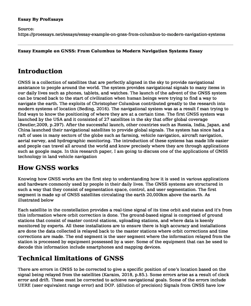
Navigation is comprised of complex systems and after understanding how it works it is important therefore, to explore some of the areas it is used. As technology continues to grow and expand, so is the human need for comfort and luxury. The arrival of autonomous vehicles has been the epitome of navigational importance (Dresner,2007, p.1268).). These self-driving vehicles from various companies and countries utilize the navigational capabilities of the GNSS systems to navigate streets without a human driver. The GPS can be found in many application areas where the risk of accidents makes it practical to use driverless cars for access i.e. mining. Before the introduction of the GNSS, navigation systems were very expensive and were only used in the military these navigation systems can now be found in major developed countries and as the world continues to advance driverless cars will be a breakthrough and a preference for many throughout the world. Many studies and research on vehicle navigation systems began way back in the 1970s through most of the countries failed to pursue the dream further after the 1980s due to its high cost. The accuracy of a vehicle's mapping system is determined by the quantification of errors from the car sensor computation errors that cause the positioning error. vehicle navigation system, viewed May 15, 2020, <www.semiconductorstore.com>.
The image above shows where a signal is received from a system in the autonomous vehicle where a dedicated computer determines the exact position of the vehicle and the user can see the information on an electronic display.
These map-making logarithms can make navigation easy by giving an approximate location and how positioning error can be eliminated (Huang,2018, p.29.). The navigation systems enhance the accuracy of the driver and autonomously driven vehicle to reach their destination efficiently the main components of a vehicle navigation system include a user interface to key in the destination, a receiver that determines the precise location of the vehicle and sensors attached or embedded in the vehicle to determine means and ways to pass through a given space. The system also has access to a database with a digital map for the determination and maneuver of routes. The GNSS has used on essentially all vehicles in the market all over the globe as discussed early, GNSS corrections can be applied and used in enhancing the accuracy of the system. Some of the applications of GNSS in land vehicle systems are vehicle tracking. The tracking sensor has a GNSS receiver which together with other components that calculate the optimized position.
GNSS can also be used in inertial systems and sensors. The use of such technology in automotive engineering is called “dead reckoning” which involves deducing one’s positioning applying the knowledge of course and distances to a location or position previously known. Inertial sensors calculate variations such as direction, speed, and orientation. In the future, there will be vehicles in driveways with no drivers at all either doing emergency work or just carrying a passenger on holiday.
Case study
The use of GNSS has expanded human knowledge into driverless cars which satellite navigation systems to make cars that do not need drivers to steer them in the right direction. Many motor vehicle companies have adopted the technology to provide care in the future that will be driverless to do an array of activities such as the delivery of packages. Some of the applications of GNSS such as self-parking and lane control have been integrated into tesla cars to provide a good driving experience for its drivers. All tesla vehicles are fitted with hardware that can enable full self-driving when the need arises (Endsley,2017, p.238.). Some of the vehicles however have experienced mechanical glitches and veered off the road. The benefit has been to be able to attend to emergencies and be able to safely reach your destination while still in the car. People have tuned cars into offices and move about doing their work without missing out on deadlines.
Conclusion
The application of GNSS in many navigational systems around the world has helped to fuel innovation in the technology of pinpointing the location of people or things. Through these systems, it has been easier for people to get around and meet each other even in places not visited before. The application of the systems has not only ended there but in recent years’ vehicles that relay on GNSS systems for navigation have been invented and are proving practical in many ways intending to reduce accidents and eliminate human error. More research and development is needed in the area to focus on ways the system can even be made better through the elimination of positioning errors to open an even bigger avenue for innovation.
References
Endsley, M. R. (2017). Autonomous driving systems: A preliminary naturalistic study of the Tesla Model S. Journal of Cognitive Engineering and Decision Making, 11(3), 225-238.
Dresner, K. M., & Stone, P. (2007, January). Sharing the road: Autonomous vehicles meet human drivers. In Ijcai (Vol. 7, pp. 1263-1268).
Huang, Xingyu, Yong Li, Yue Wang, Xinlei Chen, Yu Xiao, and Lin Zhang. "CTS: A cellular-based trajectory tracking system with GPS-level accuracy." Proceedings of the ACM on Interactive, Mobile, Wearable and Ubiquitous Technologies 1, no. 4 (2018): 1-29.
Vukovic, J., Basta, E., Katalenac, A., and Kos, T., 2019, September. Alternatives for GNSS Timing in Croatia. In 2019 International Symposium ELMAR (pp. 199-202). IEEE.
Karaim, Malek, Mohamed Elsheikh, Aboelmagd Noureldin, and R. B. Rustamov. "GNSS error sources." Multifunctional Operation and Application of GPS; Rustamov, RB, Hashimov, AM, Eds (2018): 69-85.
Hoque, M. Mainul, and Norbert Jakowski. "Estimate of higher-order ionospheric errors in GNSS positioning." Radio Science 43, no. 05 (2008): 1-15.
Groves, P.D., 2015. Principles of GNSS, inertial, and multisensor integrated navigation systems, [Book review]. IEEE Aerospace and Electronic Systems Magazine, 30(2), pp.26-27.
Bedding, S.A. ed., 2016. The Christopher Columbus Encyclopedia. Springer.
Beutler, G., Moore, A.W., and Mueller, I.I., 2009. The international global navigation satellite systems service (IGS): development and achievements. Journal of Geodesy, 83(3-4), pp.297-307.
Cite this page
Essay Example on GNSS: From Columbus to Modern Navigation Systems. (2023, Aug 08). Retrieved from https://proessays.net/essays/essay-example-on-gnss-from-columbus-to-modern-navigation-systems

so we do not vouch for their quality

If you are the original author of this essay and no longer wish to have it published on the ProEssays website, please click below to request its removal:
- Privacy Risk With Social Media Essay
- Essay Sample on AI Revolution: How Artificial Intelligence is Changing the World
- Essay Example on Ancient Egypt & Mesopotamia: Male-Dominated Societies
- Athens Defeats Persia in First Persian War - Essay Sample
- Essay Example on Israel-Palestine Conflict: A Century-Old Dispute Over Land
- Essay Example on Shays' Rebellion: Farmers vs Gov't in 1786-87
- Paper Example on Erving Goffman: A Canadian-Ukrainian Jew and His Rise to Fame


